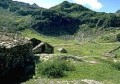
Česky
| English
www.boudy.info
Open database of mountain huts, bivouac sheds and bivouacs
Index
Search for object
Add an object
View map
Export GPS
Alpe Campo
Italy, Alpi Pennine, Valgrande, Val Artogna | 1 890 m
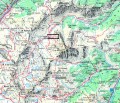
Map
Can not display map !!!
To view the map Javascript is required...
Objects around
aXcYTwHRCDeXDsm
4.1 km, ↘ 183 m
aXcYTwHRCDeXDsm
7.2 km, ↗ 670 m
Alpe Sella Alta
7.6 km, ↗ 157 m
Ravelli L.
8 km, ↗ 613 m
Alpe Toso
8.9 km, ↘ 241 m
Axerio
11.9 km, ↗ 782 m
Antoniotti
12 km, ↗ 666 m
Lanti E.
12.3 km, ↗ 235 m
Lateltin U.
13.6 km, ↗ 1242 m
Alpe Cavaglione
14.1 km, ↘ 259 m
There was found 10 objects if you know any other, try to add it here...
Add new object
Main informations
12
15
GPS WGS84:
45° 47’ 43.87” N 7° 57’ 25.74” E
Submitted by:
Kája (03.02.2005)
Edit object
Notes
For this object is not here yet no note, so if you know something, try to add it here...
Add a note
Photogallery
Upload a picture
Description of object
Notes
1
2
(2008)
©
www.boudy.info | all informations without guarantee | PHP 5.6.40-70+ubuntu20.04.1+deb.sury.org+1 | last change: 17.01.2022 19:41:24 V.A.