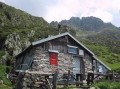
Česky
| English
www.boudy.info
Open database of mountain huts, bivouac sheds and bivouacs
Index
Search for object
Add an object
View map
Export GPS
Aprica
Italy, Prealpi Lombarde, Cima Cadin | 1 750 m
Map
Can not display map !!!
To view the map Javascript is required...
Objects around
aXcYTwHRCDeXDsm
7.3 km, ↗ 820 m
aXcYTwHRCDeXDsm
8 km, ↘ 298 m
Pian della Valle
8.1 km, ↘ 574 m
aXcYTwHRCDeXDsm
11.4 km, ↗ 150 m
aXcYTwHRCDeXDsm
13.1 km, ↗ 266 m
Corti A.
13.7 km, ↗ 749 m
There was found 6 objects if you know any other, try to add it here...
Add new object
Main informations
15
20
GPS WGS84:
46° 7’ 1” N 10° 9’ 9.8” E
Submitted by:
Kája (29.04.2004)
Edit object
Notes
For this object is not here yet no note, so if you know something, try to add it here...
Add a note
Photogallery
Upload a picture
Description of object
Notes
1
2
©
www.boudy.info | all informations without guarantee | PHP 5.6.40-70+ubuntu20.04.1+deb.sury.org+1 | last change: 17.01.2022 19:41:24 V.A.