Česky
| English
www.boudy.info
Open database of mountain huts, bivouac sheds and bivouacs
Index
Search for object
Add an object
View map
Export GPS
Nebbia F.
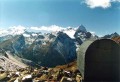
Italy, Alpi Graie, Mt. Emilius | 2 850 m
Map
Can not display map !!!
To view the map Javascript is required...
Objects around
Grauson - Tentori
3.8 km, ↘ 310 m
Bivacco Federigo
4.8 km, ↗ 57 m
Menabreaz E.
7.7 km, ↘ 296 m
aXcYTwHRCDeXDsm
7.8 km, ↗ 348 m
Gontier M.
9.7 km, ↘ 541 m
aXcYTwHRCDeXDsm
9.8 km, ↗ 627 m
Bivacco Davito P.M.
11.7 km, ↘ 490 m
aXcYTwHRCDeXDsm
11.9 km, ↘ 262 m
aXcYTwHRCDeXDsm
11.9 km, ↗ 66 m
aXcYTwHRCDeXDsm
12.1 km, ↗ 70 m
aXcYTwHRCDeXDsm
13.3 km, ↗ 22 m
aXcYTwHRCDeXDsm
13.7 km, ↗ 15 m
aXcYTwHRCDeXDsm
13.7 km, ↗ 350 m
Sberna S. e R.
14.3 km, ↗ 554 m
Bivacco Borghi S.
14.4 km, ↘ 164 m
aXcYTwHRCDeXDsm
14.5 km, ↘ 240 m
There was found 16 objects if you know any other, try to add it here...
Add new object
Main informations
6
10
GPS WGS84:
45° 38’ 45.6” N 7° 21’ 10” E
Submitted by:
Kája (04.02.2005)
Edit object
Notes
For this object is not here yet no note, so if you know something, try to add it here...
Add a note
Photogallery
...
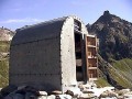
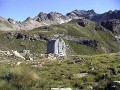
The gallery includes 3 files, if you have any more, you can upload it here...
Upload a picture
View the gallery
Description
...
Edit description
Water supply
...
Edit parameters of water
The best time to visit
...
Edit the visit
Access
3 h 30 z Epinel.
Edit access
©
www.boudy.info | all informations without guarantee | PHP 5.6.40-70+ubuntu20.04.1+deb.sury.org+1 | last change: 17.01.2022 19:41:24 V.A.