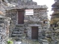
Longa B.
Italy, Alpi Pennine, Val Anzasca, Monte Marigal | 2 036 m
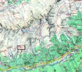
Map
Objects around


There was found 15 objects if you know any other, try to add it here...
 Main informations


8
12


GPS WGS84:
45° 58’ 43.07” N
8° 4’ 9.77” E
Submitted by: Kája (03.02.2005)
Last update: K (29.12.2011)
Submitted by: Kája (03.02.2005)
Last update: K (29.12.2011)
Photogallery
© K
(2011)
The gallery includes 2 files, if you have any more, you can upload it here...
Notes
For this object is not here yet no note, so if you know something, try to add it here...
© www.boudy.info | all informations without guarantee | PHP 5.6.40-70+ubuntu20.04.1+deb.sury.org+1 | last change: 17.01.2022 19:41:24 V.A.