Česky
| English
www.boudy.info
Open database of mountain huts, bivouac sheds and bivouacs
Index
Search for object
Add an object
View map
Export GPS
Bouda mezi Kozlovice a Tichou
Czech Republic, Beskydy, Štramberský vrchovina, Mezi Kozlovicemi a Tichou | 464 m
Map
Can not display map !!!
To view the map Javascript is required...
Objects around
Přístřešek na Ondřejníku
5.3 km, ↘ 464 m
Rozhledna Panorama, Chlebovice
7.9 km, ↘ 4 m
Rozhledna na Javorníku
8.3 km, ↘ 464 m
přístřešek v údolí Jičinky
9.4 km, ↗ 46 m
Bouda
9.7 km, ↘ 464 m
Přístřešek u Velké Polany
9.8 km, ↗ 481 m
Bouda pod Smrčkem
10.6 km, ↗ 206 m
Turistický přístřešek sedlo tanečnice
11.4 km, ↗ 546 m
Budka
12.1 km, ↗ 36 m
Přístřešek Albínovo náměstí
12.4 km, ↘ 464 m
Klinská
13.5 km, ↗ 606 m
There was found 11 objects if you know any other, try to add it here...
Add new object
Main informations
2
3
GPS WGS84:
49° 35’ 5.45” N 18° 14’ 25.5” E
Submitted by:
Petr Svoboda (03.11.2020)
Edit object
Notes
For this object is not here yet no note, so if you know something, try to add it here...
Add a note
Photogallery
© PetrSv (2020)
...
The gallery includes 2 files, if you have any more, you can upload it here...
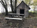
Upload a picture
View the gallery
Description
table
benches / chairs
earthen floor
open fireplace
...
Edit description
Water supply
surroundings in times of drought without water
...
Edit parameters of water
The best time to visit
...
Edit the visit
Access
...
Edit access
©
www.boudy.info | all informations without guarantee | PHP 5.6.40-70+ubuntu20.04.1+deb.sury.org+1 | last change: 17.01.2022 19:41:24 V.A.