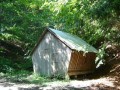
Seník nad přehradou Morávka
Czech Republic, Moravskoslezské Beskydy, masív Travného, Morávka | 673 m
Map
Objects around


There was found 11 objects if you know any other, try to add it here...
 Main informations


2
6


GPS WGS84:
49° 34’ 8.52” N
18° 32’ 13.8” E
Submitted by: Pedrera (27.07.2009)
Last update: bodddyy@seznam.cz (03.08.2020)
Submitted by: Pedrera (27.07.2009)
Last update: bodddyy@seznam.cz (03.08.2020)
Notes
For this object is not here yet no note, so if you know something, try to add it here...
Photogallery
The gallery has found only the title picture if you have any more, you can upload it here...
Description
1
Water supply
Bouda stojí u jednoho pramene řeky Morávky.
The best time to visit
Asi kdykoliv...
Access
...
- 1
© www.boudy.info | all informations without guarantee | PHP 5.6.40-95+ubuntu24.04.1+deb.sury.org+1 | last change: 17.01.2022 19:41:24 V.A.