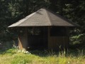
Altán u lesní cesty Střelnice
Czech Republic, Český les | 520 m
Map
Objects around

There was found 3 objects if you know any other, try to add it here...
 Main informations


Notes
For this object is not here yet no note, so if you know something, try to add it here...
Photogallery
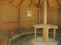
Interiér
© Millan
(2019)
The gallery includes 2 files, if you have any more, you can upload it here...
Description
- benches / chairs
- wooden floor
1
Water supply
Asi 100-150 m nad altánem ve stráni by měl pramenit přítok Nemanického potoka, ale prameniště blíže nezkoumáno. Jinak až v Nemanicích.
The best time to visit
Kdykoliv - ovšem altán je na turistické cestě (neznačené).
Access
...
- 1
© www.boudy.info | all informations without guarantee | PHP 5.6.40-95+ubuntu24.04.1+deb.sury.org+1 | last change: 17.01.2022 19:41:24 V.A.