Česky
| English
www.boudy.info
Open database of mountain huts, bivouac sheds and bivouacs
Index
Search for object
Add an object
View map
Export GPS
studánka pod Janským vrchem
Czech Republic, Javoří hory | 550 m
Map
Can not display map !!!
To view the map Javascript is required...
Objects around
hraniční přechod Petříkovice
0.5 km, ↘ 100 m
Přístřešek u Stachelbergu
7 km, ↘ 550 m
Přístřešek pod Žaltmanem
7.3 km, ↗ 135 m
Turistický altán s topeništěm
7.9 km, ↗ 140 m
aXcYTwHRCDeXDsm
8.8 km, ↗ 300 m
Převis Čáp
10 km, ↗ 206 m
Ozvěna u Teplic
11 km, ↘ 100 m
Bouda na rohu hranic
12.6 km, ↗ 400 m
Bouda u hraničního přechodu Horní Albeřice
13.3 km, ↘ 550 m
There was found 9 objects if you know any other, try to add it here...
Add new object
Main informations
4
8
GPS WGS84:
50° 36’ 51.48” N 16° 0’ 16.56” E
Submitted by:
scinkk (27.08.2013)
Edit object
Notes
For this object is not here yet no note, so if you know something, try to add it here...
Add a note
Photogallery
The gallery has found only the title picture if you have any more, you can upload it here...
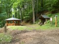
Upload a picture
View the gallery
Description
benches / chairs
1
Edit description
Water supply
Pristresek je hne du vydatneho pramene.
Edit parameters of water
The best time to visit
...
Edit the visit
Access
...
1
Edit access
©
www.boudy.info | all informations without guarantee | PHP 5.6.40-81+ubuntu20.04.1+deb.sury.org+1 | last change: 17.01.2022 19:41:24 V.A.